


historical
phx sky harbor
departure paths
For years, planes flying northeast out of Sky Harbor Airport generally followed wide flight paths. These routes flew over the Salt River, McDowell Mountains and commercial areas. These areas were low in population and few if any residential communities. These paths provided a high level of ground safety and a reduced noise contour.
The two maps at the left show the actual historical flight paths and how flights flew east of Scottsdale communities and were dispersed over a wider area.
(The three flight routes depicted have been renamed by the FAA. MAYSA is now called ZEPER, SNOBL is now called QUAKY, and YOTES is now called MRBIL)
Please scroll down


THE PROBLEM:
THE NEW NEXTGEN
PHX SKY HARBOR
DEPARTURE PATHS
At the end of 2014 the FAA implemented the NextGen program utilizing satellite navigation instead of radar. NextGen provides much more precise routes, closer spacing and more reliable technology. But it consolidated and moved three northward flight routes into one "highway" down the middle of Scottsdale to overfly residential communities and schools. The departing planes are also at lower altitudes which increases noise levels. Worse, the new paths compromise ground safety. In the event of an aviation mishap, which would be safer to ground residents: an event over the mountains or an event over homes and schools?
The two maps at the left show how the FAA moved flight paths further to the west, consolidating them and placing them over Scottsdale residential communities.
The FAA ignored common sense: use natural uninhabited and available terrain for airplane overflights to reduce noise contours to the public and provide optimum ground safety.

The map to the left is an enlarged version of one of the historical flight path maps above. The old routes placed few flights directly above Scottsdale communities as most flights flew over safer unpopulated mountain terrain.

This map enlargement demonstrates the NextGen consolidation of flight paths into a single highway across Scottsdale communities and how they follow the exact same path when they are northbound. Any unfortunate aviation mishap would now occur over populated residential communities, schools, parks and recreational facilities..
JANUARY, 2017
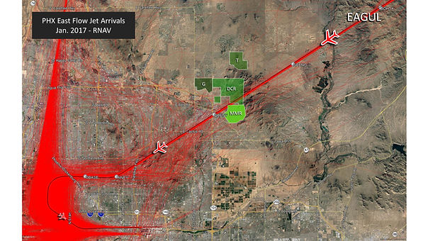
PHX sky harbor arriving planes
Aircraft on the arrival path are at a higher altitude than the departing aircraft, resulting in the departing aircraft flying beneath the arrivals causing them to be closer to the ground with safety and noise compromised.
This map shows the paths of arriving flights from the northeast. This route was implemented prior to the NextGen departure routes shown above. This demonstrates that the same Scottsdale communities were given a double whammy from the FAA by exposing them to both departure and arrival aircraft noise at the same time.

SEPTEMBER, 2014
SCOTTSDALE AIRPORT
Air traffic noise at Scottsdale Airport is more complex due to the number of communities bordering the airport. This map shows the typical arrival path (yellow) and typical departure path (green) at the Airport prior to NextGen implantation at Sky Harbor. The airport has wide flight path corridors that planes can fly within.

FEBRUARY, 2015
SCOTTSDALE AIRPORT
This map show the changes in the typical arrival and departure paths after NextGen implantation at Sky Harbor. The NextGen changes caused the Scottsdale Airport arrivals (yellow) to be moved further east and the departures to be moved further west within the flight corridors. This caused aircraft noise to be transferred to residents that had little noise previously. SCANA recommends that the paths be moved back to the original routes within the corridors once the NextGen paths from Sky Harbor are reinstated to their original locations.